My Blog List

Sunday 26 September 2010

Glaciers: Then and Now

The links below show a matching photo's activities. The activities require students to identify different glaciers. There are two pictures of a glacier one from modern times, and a photo from 50-100 years prior. The activity teaches skills of photo analysis and identifying physical features from photos.


This link is the teacher resource explaining the activity and how to go about setting the activity up.


This is the resource, with the photos, worth looking at these, as they show the photos, and it is amazing to see the difference of over time.


Glacial evidence in the UK

One problem with teaching glaciers, is that we are no where near a glacier and so it is difficult to enthuse students about glaciers. Glaciers have no immediate effect on our lives. However as some of us know, this is not the case as evidence of a glacial past is in the UK, especially in the Lake District.


This is a Corrie called Red Tarn in the Lake District.

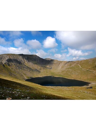
Snowflakes collect in a hollow. As more snow falls, the snow is compressed and the air is squeezed out to become firn or neve. With the pressure of more layers of snow, the firn will, over thousands of years, become glacier ice. Erosion and weathering by abrasion, plucking and freeze-thaw action will gradually make the hollow bigger.

Even though the ice is trapped in a hollow and unable to move down hill, gravity will still encourage it to move. This circular motion is known as rotational slipand can cause the ice to pull away from the backwall creating a crevasse or bergschrund. Plucked debris from the backwall causes further erosion through abrasion which deepens the corrie.


Some of this debris is deposited at the edge of the corrie, building up the lip.

These processes create a characteristic rounded, armchair shaped hollow with a steep back wall.

When ice in a corrie melts, a circular lake is often formed at the bottom of the hollow.

This description ts taken from BBC Bitesize, where there is also a diagram demonstrating the formation of a corrie.

http://www.bbc.co.uk/schools/gcsebitesize/geography/glaciation/glacial_erosionrev1.shtml


Key Term Art

Hello, I've recently found this great website called http://www.wordle.net/

The website is a great way of displaying key words and themes of a subject in a cool way. By detecting popular words from a piece of text, it displays the most used words the biggest.

For example, I made one for Glacier terminology using a website of definitions (http://vulcan.wr.usgs.gov/Glossary/Glaciers/glacier_terminology.html)

And this is what i got:

Wordle: TomGlacier
A bigger version can be seen at this link: 

Have ago at creating your own and let me know what you think?


Monday 23 August 2010

Hello everyone,

Sorry for no blog for awhile, I have been in Italy for 3 weeks. Climbed up Mount Vesuvius (very cool), should have done Volcanoes really got some great pictures.


But anyway, I'm now back to look at different ways you could teach glaciation.

Teaching Glacial landforms

This is an interesting technique which I found on a website, it would work well as a finishing activity to do for a lower school KS3 lesson. It helps students remember some key landforms from glacial erosion.

The activity is a physical activity, which gets students to do different actions for each landforms, the activity is known as 'Kung-fu Glaciation', here is some of the actions:

  • Funky snowflake: Jump up and down pretending to be fluttering downwards.
  • Ice: Jump into position as if on a snowboard and shout "ice"
  • Basal slippage: Wiggle your hips in a circular motion.
  • Corrie: Make a cutting action across your body with a cupped hand.
  • ArĂȘte: Make a cutting action downwards.
  • Pyramidal peak: Thrust your arm in the air.
Then you have to put all the moves together to show how the landforms are created.

For example: Snow falls and compacts to form ice. The ice erodes the rock by basal slippage to create a corrie. Two corries together form an arĂȘte, and three corries together form a pyramidal peak!

This activity would be useful during a morning lesson to waken the students up to the lesson. It also appeals to different styles of learning such as Visual and Kinesthetic learners. By seeing actions and doing different actions names of landforms are more likely to stick in the students heads.

On the website there is a power point presentation looking over different landforms, and a link to a Glacial sort card, which requires students to match landforms with their definition:

Sunday 25 July 2010

Glacier system and Key Vocabulary


This Systems Diagram is taken from S-cool revision website and shows the key Inputs, Processes and Outputs, which occur in glaciation.


Key Vocabulary

Ablation - The melting of the ice, mainly during summer months, and usually at the snout end of the glacier.

Accumulation - The build up of the glacier due to snow being compacted into ice.

Calving - The splitting of the end of the glacier into smaller sections. These could become icebergs, if the glacier snout ended in the sea. .

Glaciation - The effect of large masses of ice on the landscape. Compressed snow accumulates to eventually form ice and create a glacier.

Ice Sheets - These are large masses of ice which cover an entire land surface. Antarctica is the best example as the ice sheet covers the entire continent.

Snout - the lower end of the glacier.

Valley Glaciers - The most common of the two types of glacier. These are confined by the valley sides that have already been carved out by a river. Valley glaciers can be found in all the main mountain ranges of the world, such as the Franz Josef Glacier in the Southern Alps of New Zealand, and the Rhone Glacier in Switzerland.

Tuesday 13 July 2010

Introduction to Glaciers

A Glacier is: ' A tongue shaped mass of ice moving slowly down a valley.' (Redfern, D and Skinner, M. 2005)


Glaciation occurs in areas of permenant snow. This is normally at high altitude, where the climate is cooler. In the northern hemisphere south facing mountains, a snow line will occur due to the south facing side recieves more insolation. As the snow line builds it becomes more compact, and with meltwater, it freezes and becomes more compact ( this can take between 20-40 years). As the air is expelled from this area of ice, the ice begins to flow downhill as a glacier.


This video, from the National Geographic Channel, shows the power of a glacier. It shows the glacier from underneath. From it you can get an understanding of how the glacier moves across the landscape.

Monday 5 July 2010

My first blog - Introduction

Hello everyone,

I'm Tom, I live in Leicester and am going onto do my PGCE teacher training for Geography Secondary school in september at the University of Leicester.

Over the summer I am hoping to learn as much as I can about glaciation. I have never really studied in great depth before, and so I'm quite looking forward to it. At the moment my knowledge is relatively low, but I can tell you now, snow and ice are involved, and I know Fjords are an outcome after the glacier has gone. So over the next couple of months, I hope to learn a lot more regarding the subject.

Look forward to reading other peoples blogs and speak to you all soon

Tom